About This Claim
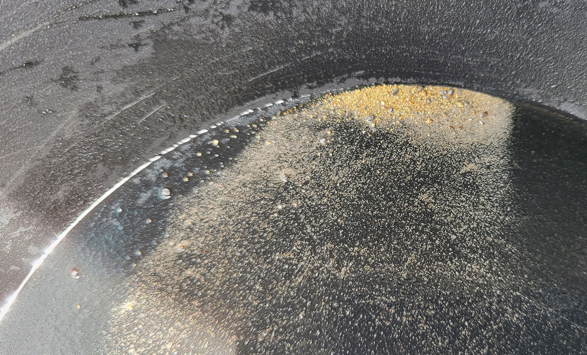
Little May Gold Project Yavapai County, Arizona 67 Acres Arizona State Land + 20 Acre Federal Mining Claim Little May Gold Project - https://littlemaygold.com Overview The Little May Gold Project is a historically documented gold and silver exploration and development opportunity located in the western foothills of the Bradshaw Mountains near the Hassayampa River in Yavapai County, Arizona. The project is positioned within a historically productive mineral district between the renowned Octave and Congress mining regions and consists of 67 acres under Arizona State Land mineral lease control, along with one adjoining 20-acre federal mining claim. Over the past five years, the project has been systematically advanced through historical research, field validation, surface sampling, geological mapping, and direct exploration by owner and developer Eric Schultz of Schultz Resource Management. What makes the Little May Project unique is the presence of extensive mineralized material readily accessible at surface. Multiple vein systems, exposed ore structures, and historically stacked ore are present throughout the property, significantly reducing the need for large-scale early-stage underground development. This surface accessibility has the potential to save millions in traditional mine development costs while creating a realistic pathway toward near-term bulk exploration and phased operational advancement. Historical Foundation The Little May property was historically explored and documented by Harry W. Fisher beginning in the early 1900s. Historical reports, engineering notes, and field observations from the 1940s describe substantial quartz vein mineralization containing free-milling gold, silver, sulfides, iron pyrite, hematite, galena, and associated mineral values. Two historical non-commercial bulk samples reportedly returned: * Westerly sample: approximately 0.5 ounces gold per ton * Easterly sample: approximately 1 ounce gold per ton Historical engineering reports also documented approximately 24 samples ranging from 0.01 to 2 ounces of gold per ton. Supporting documentation includes work and observations by: * Harry W. Fisher * B.W. Brown, Field Engineer * A. Macfarlane, Arizona Field Engineer * Arthur Clark, Mining Engineer Copies of historical reports and supporting documentation are available upon request. Modern Exploration and Verified Mineralization Recent fieldwork and exploration conducted by Eric Schultz has substantially expanded the understanding of the property and verified multiple mineralized targets. Current findings include: * Eight verified surface vein targets * Vein widths ranging from approximately 6 inches to 48 inches * Multiple historically stacked ore zones at surface * Visible free-milling gold observed during field processing and panning * Presence of sulfides and silver-bearing mineralization * Recently identified higher-grade silver vein returning approximately 4 ounces silver per ton Professional assay work from recent sampling has returned values ranging from approximately 3 to 21 grams gold per ton. All recent sampling has been GPS-referenced, documented, field processed, and professionally assayed through a regional Arizona analysis facility familiar with local geology and ore systems. Geology and Structure Mineralization occurs primarily within quartz vein systems hosted in Bradshaw Granite and monzonite porphyry with associated rhyolite and diabase dikes. Documented mineralization includes: * Free gold * Silver * Iron pyrite * Hematite * Galena * Copper and associated sulfides The project contains multiple exposed vein structures visible throughout the canyon system. Erosion and topography have naturally exposed portions of the mineralized system, providing direct access to material at surface. The nearby Octave and Congress mines historically produced ore from depths exceeding 2,000 feet. Based on structural observations, declivity, and erosion exposure within the Little May canyon system, the mineralized structures are interpreted to potentially extend substantially below current exposures. Octave mine produced 200,000 ounces. Development Philosophy and Opportunity The Little May Gold Project is being advanced under a practical, low-overhead development model focused on direct field progress rather than excessive capital deployment. Current development plans include: Continued mapping and sampling Controlled bulk exploration Lightweight access improvements Portable core drilling and structural analysis ATV-supported transport systems Selective surface material evaluation and extraction The owner believes the combination of: Surface-accessible ore Historically documented values Modern assay confirmation Low-cost development potential High gold pricing environment creates an unusually favorable near-term opportunity for continued exploration and phased development. Current Status The project is currently moving toward development.
Claim Details
Access & Operations
Access Notes
The road needs to be partially improved in sections where erosion has made it impassable by vehicle. Current access partial ATV and foot. Parking lot to claim are is 1.5 mi. easy walking through rolling terrain along the old road path.
Seasonality
Best season is October though March.
Water Rights
No water - river nearby.
Verification Status
This listing is provided by the seller and has not been independently verified. Buyers should verify all information with official sources before purchase.
Similar Claims in Arizona
Coming soon: Similar listings recommendation